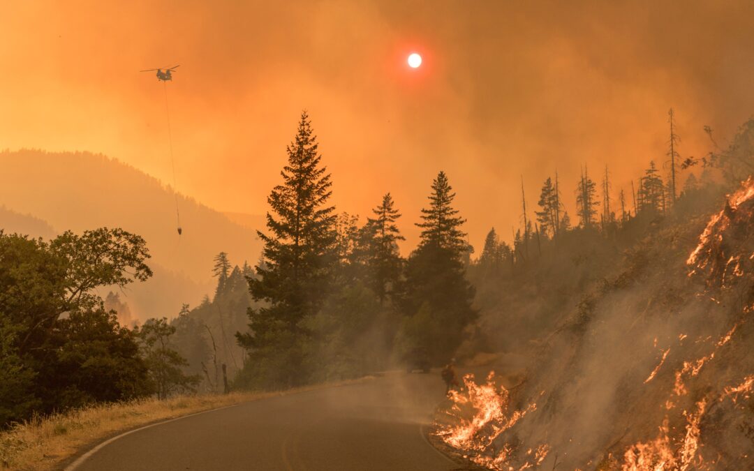
(Photo Source: Forest Service NW via Twitter)

Chris Crew was born in Morganton, NC and moved to Raleigh in 1964. He’s been a resident of Historic Oakwood since 1975.
Educated at NCSU and UNC-Chapel Hill and is retired from Public Safety. Preservationist, Cook, Trombonist, Brewer, Choirboy, Grandfather.
Chris submitted this blog for publication:
“And I will shew wonders in the heavens and in the earth, blood, and fire, and pillars of smoke”
Joel 2:30
The recent devastation of Los Angeles and the periodic destruction of property elsewhere in California and the western states begs the question — could it happen in Raleigh?
A wildfire is defined as an unplanned, uncontrolled and unpredictable fire in an area of combustible vegetation. The North Carolina Enhanced Hazard Mitigation Plan, and all 33 FEMA-approved and adopted Regional Hazard Mitigation Plans covering all 100 counties and some 97% of municipalities of North Carolina identify wildfire as a hazard. You can view these plans at: Hazard Mitigation Plans
The wildfire risk assessment begins on page 181 of the Wake County Multi-Jurisdictional Plan. Annually, North Carolina loses about 15,000-20,000 acres to wildfire. In my 26-year experience with NC Emergency Management, a single residential structure, a few commercial buildings and a handful of agricultural buildings have been lost to wildfire. Contrast this with California, which lost 17,000 acres, and over 1,000 homes in a single night in January of 2025, and it would seem that we don’t have a lot to worry about. Several factors need to be considered in making this comparison. California is about 100 million acres; 52 million for NC.
About 48 million acres of California is publicly owned and managed, about 5 million in NC—the bulk of which is forest or woodland and sparsely populated. The majority of wildfire acres burned annually in NC are on public land such as National Forest or Parkland, thus few structures tend to be threatened.
Land management practices and climate are two principle factors to weigh in a wildfire risk analysis. The climate in California has been fairly predictable for the last 200 years; NC’s climate has been characterized by fairly changeable weather for 1200 years based on tree ring data and other sources. Most of California experiences a definite wet and dry season, and winds predictably blow off of the ocean onto land for half of the year, and in from the desert for the other half.
Land management practices include both forestry management and land use planning (zoning and consideration of development patterns). The location of wildfire risk can be defined by the acreage of Wildland and Urban Interface (WUI). The WUI is described as the area where structures and other human improvements meet and intermingle with undeveloped wildland, woodland, or vegetative fuels and thus demarcates the spatial extent of wildfire risk. About 6.5 million acres in California meet the WUI criteria (6.5% of the total land area); about 13.5 million acres in NC meet the WUI criteria (27% of the total area). In fact, NC is reported to have the largest amount of WUI of any of the 50 states. Talk about superlatives! The Southern Wildfire Risk Assessment estimates that about 96% of Wake County’s population lives in a WUI and suggests that the expansion of residential development from urban centers out into more rural and wooded landscapes increases the potential for wildland fires to threaten development.
Wildfires are categorized by intensity from 1 to 5, 1 being the lowest. Class 1 fires are described as very small, discontinuous flames, usually less that one foot high, spreading slowly and not as a result of flying embers. They are typically easy to suppress with basic firefighting equipment and skills. Class 2 fires have flames usually less than 2 feet high, exhibit a small amount of short-range spotting (spreading by flying embers) and are easily suppressed by trained firefighters with protective equipment and specialized tools. Class 3 fires have flames up to 8 feet high and are difficult to suppress with support from aircraft, specialized engines, dozers and plows. Class 4 fires show flames up to 30 feet high, medium range spotting; direct ground attack is generally ineffective; indirect attack (containment) is generally effective with fires of this class and they present significant potential for harm or damage to life and property. Class 5 fires may exhibit flames up to 150 feet high, profuse short-range spotting and frequent long-range spotting; there are strong fire-induced winds, indirect attack is marginally effective and there is great potential for damage and loss of life.
At the County level, about 7% of Wake Co falls into a risk of up to Class 4 fire intensity, and over 22% of the County may be subject to risk of fires up to Class 3 intensity. Raleigh inside the beltline, North Raleigh and Southeast Raleigh fall into the 1-1.5 intensity risk area; parts of Southwest Raleigh reach the 3.5-4 category risk level.
Weather patterns (drought and Santa Anna winds blowing at nearly 100 mph) contributed greatly to the destruction witnessed these last few days in California. With a few very local exceptions, NC generally only experiences winds over 40 mph while it’s raining really hard at the same time. In reviewing video of the California fires, I saw considerable evidence that relatively low flames reached “ladder fuels” (both vegetation and construction including outbuildings, elevated wooden walkways, stairs and decks) leading to structural involvement.
Could Raleigh experience a devastating wildfire? Yes.
Is there anything we can do to mitigate the risk? Yes.
For the last 1200 or so years, NC’s weather swings regularly from excessively wet to excessively dry and back again on about a 5-to-15-year cycle (we know this from tree ring data and other analysis). The highest danger of wildfire occurs during periods of excessive drought and is demonstrated over a short term in the higher number of acres burned in 2010, 2011, 2012, 2017 and 2018—all excessively dry years. 2024 and 2025 to date have been statistically excessively dry, hurricanes and tropical storm events notwithstanding. Changing weather patterns due to climate change will necessarily make the math turn weird. Recently, the National Weather Service has began to discuss the concept of “flash drought.” Drought generally occurs over a timeframe of years from drying out to getting wetter again. Recent fluctuations in excessive heat seem to point to faster onset of drought conditions informally described as a flash drought. During these periods, susceptibility to wildfire necessarily increases. How do we mitigate the threat? Land use planning, zoning and code enforcement. Consider where and how to build. Insist on fire-resistant construction, especially in choices of roofing and siding material. Create defensible space between buildings and flammable vegetation. Limit places like eaves and soffits where burning embers could lodge. Choose less-flammable landscape plants and materials (don’t mulch with pinestraw). Be extremely cautious with outdoor burning including grills and firepits. Pay attention to weather advisories. Maintain insurance.
Support your local firefighters.
And most important: if you receive an evacuation notice from local Emergency Management Authorities, grab the dog, your pills and your passport and MOVE IT!
If you appreciate the kind of reporting we bring to you
|
Please donate $10 or $20, Thanks for supporting |
 |