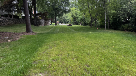
The streamside option route-photo from a recent news story by CBS17.com

North Carolina native George Jeter is a former reporter and retired state government writer and editor. He and his family have lived in Raleigh’s Crabtree Heights neighborhood for over 30 years.
Mr. Jeter submitted the following in regards to the Big Branch Greenway Connector Project for publication:
NOTE – Livable Raleigh has not taken a position on this project. We have published the opinions from two different neighborhood groups to keep you informed of the various options. What we do support is full public engagement by the city and proceeding based on the results of that engagement.
The other opinion is here. From Anderson Forest: Oppose ALL options
The “Streamside Option” is The Only Safe and Scenic Choice for the Big Branch Connector Greenway Project
The Parks and Recreation Section of the City of Raleigh website is currently promoting the completion of the “Big Branch Connector” greenway section. Putting a greenway section through this part of Raleigh has been on the greenway books since the plan was announced back in the 1970s. Through the following decades, the city proposed several different exact routes for that piece of greenway. It has discarded some of those past proposed routes, for reasons unclear.
One route that has always stayed in the proposal is what is now known as the “Streamside Option.” However, sometime in the past year the city very quietly inserted two new, never before considered route options. Both of these options cut through the long-established Crabtree Heights neighborhood. A neighborhood that was developed and built out before the city ever began greenway planning.
Residents of the neighborhood only heard that they were in the possible trail development pathway a few weeks ago. One of these two new options would cut through the front yards of houses on Belvin Drive and Plantation Road and through a daycare business. The other of these two new options would cut through front yards on Hines Drive and Plantation Road and through the daycare business.
If the city selects either of the two options going through this neighborhood, it will be devastating for a long surviving Raleigh neighborhood and it will be a radical, very un-greenway greenway project. Either of these two options would be more of an urban path than actual greenway as the trail would move along roads, across one street, and require the cutting down of many of the currently surviving trees and bushes in the neighborhood, leaving a pavement-centric greenery-bare trail.
Worse, since no such greenway trail has ever been done in Raleigh, many legal, and most importantly serious trail user safety risks would arise if either of these options were selected.
The project by the city to build this new section of greenway proposes to connect Wake Towne Drive to Six Forks Road. The City of Raleigh website on the project is at Big Branch Greenway Connector . Neighbors in the Crabtree Heights neighborhood are unified in asking people visiting the site to vote for the streamside option. They are asking city officials to do the same or take the connector project back to considering other options altogether.
The “streamside” option along the Big Branch creek would route the connector across city and little used private pieces of land. It already looks like a greenway and avoids car and truck traffic. The two other options the city lists would bring greenway users into regular contact with cars, trucks and service vehicles.
If one visits the area, a walk to the creek on Belvin Drive will show the visitor that the streamside option already looks exactly like Raleigh’s other greenway sections. A choice of the Belvin/Plantation option or the Hines/Plantation option would remove greenway users from the creek area and again, put them directly into typical city neighborhood traffic flow.
The costs of creating a path through the second two choices, risks that would be created to people using either path of the two street choices, and maintenance nightmares created by using either of these two choices would be asymmetrically higher versus using a piece of land above large city sewer pipe where there would be few complications either in creating or maintaining the path.
The city’s proposals indicate that homeowners would be affected in any of the three choices. This is true, but the streamside choice affects homeowners’ backyards, often at a distance. The roadside choices place the “greenway” through front yards in every single case, which would include traversing multiple driveways and going over one city street.
This means the paths in two roadside choices would travel over buried utility lines, over junction boxes for google fiber and ATT lines as well as buried power lines, and water and sewer connections. Users of either the roadside choice would find a path that travels over differently paved and maintained driveways, behind mailboxes, behind cars parked on the street, behind parked visiting and working vehicles on the street. And looks like even a couple of power poles would need to be relocated. Either of these two roadside choices would mean greenway users would have to cross Plantation—a public street—to stay on the path. Homeowners and vehicles related to them would need to cross the path every single time to enter or exit their driveways—an incredible safety risk. Not to mention trash cans being out every week and the scenic quality of the view being reduced greatly as trees and plantings will be destroyed to pave a greenway trail to a very visible level.
On Belvin, Hines, and Plantation, the driveways that path users would be crossing are a mix of pavements, dirt and gravel. City AI renderings are vague as to whether the greenway would be cutting a paved path through them or stopping at each and every driveway and then picking up again. But if left to the homeowner’s current state of driveway, those breaks would pose a major “’wipeout” risk to bikes and skates and scooters suddenly hitting them along the way.
A legal question is also raised—can homeowners no longer have use of their driveways where the greenway path crosses them? After all, how does one park a car in their driveway at all where the crossing takes place? It would block the route. In some cases, this would mean the city has taken a big chunk of the homeowners’ useful driveway space.
Even worse, it would not be a matter of “if” but “when the first” accident happened involving drivers in driveways colliding with path users. In the case of the author of this article, my family uses our driveway 6-8 times a day on Plantation. Our neighbors on either side have small kids and they both come and go far more than that. Most of the homes on Belvin and Plantation are as active or more active in coming and going than my family is. I think it is conservative to guess that means in either roadside option homeowners in total would be crossing the path 60 to 80 times a day in motor vehicles—all day every day all year in every kind of weather. That does not even count path users in either roadside option spilling out onto the roadbed of Plantation, which would have to be crossed in either option to complete the path’s use.
In addition, in either roadside option, the path would eventually cross a very busy daycare business entrance/exit that is probably used another 60 to 80 times a day. This means that there would be hundreds of times a day when the possibility of a collision with path users could happen. If the city chose to try to mitigate that risk by moving the trail to the other side of Plantation, then trail users would have to cross over the dual entrance/exit to an entire office park—the most busy driveway cut in the entire neighborhood.
Plus visibility is limited in all of the driveway areas because the entire neighborhood is hilly and driveways are either rising above the road or dropping below the road.
It is impossible to think that a bike or electric scooter riding at 10 to 15 miles an hour going over a different kind of driveway every few seconds would result in safe outcomes. Such travelers suddenly appearing in the middle of one’s driveway as drivers are backing out or entering from around a corner or piece of fence or clump of bushes—well, it is a recipe for disaster plain and simple. Choosing that high level of risk when it could be easily avoided by the streamside option would mean the city chose an obviously and recklessly dangerous route. Either roadside option would result in injury at some point and this writer will be the first person to say I would testify that the city chose danger over safety. I do not think that currently there is a single city greenway route built over private driveways in older neighborhoods. Is there any such existing route?
In addition, would homeowners own/maintain/have any responsibility for those parts of their driveways or yards? After all a greenway is something far bigger and more heavily used than a city sidewalk. Something where electric bikes and scooters are encouraged. How would maintenance be allowed on everything from the driveways to junction boxes to the strip of land shown in the AI renderings as being past the proposed path, between it and the street? Has anyone ever heard of a homeowner being responsible for maintaining, mowing and trimming on a greenway, although that is something implied by the AI art.
And again, at the end of either of the roadside choices there is a daycare center in operation. Either of the roadside choices would send the path immediately along the fence to the children’s play area. This means travelers and children would be right next to each other all day. This is a terrible idea. Such a thing would be inherently unsafe to those children in fact.
The center would most likely lose some parking too given the wide strip of land needed to create a greenway and parents fill that lot completely twice a day every day dropping off and picking up children. None of these obvious dangers and risks and legal gray zones would be true with selecting the choice along the creek. That land is vacant because there is city sewer pipe under it. Nothing can be built over it except for a greenway path. There are no cars, no streets to cross, no utilities to move, and it is far more peaceful and scenic to walk along a creek than dodge vehicles entering or leaving driveway cuts as one travels among parked cars and trash cans and maintenance crews.
After all you cannot be hit by a car where there are no cars. You cannot relax as you walk or bike if you must remain hyper aware of multiple egress issues on the path versus a straight through the woods clear line of travel.
It remains very confusing as to why the three choices are presented as equally valid options on the city website. It remains confusing as to how the street options even got added to the mix after all these decades. The city has remained silent as to that so far.
What is not confusing is that the only reasonable and safe choice is the streamside one. Again, it looks like most of the other greenway sections in Raleigh—a nice trail along a creek with no street legal vehicle traffic. This option would provide the relaxing greenway experience that everyone expects when they choose to travel via the city park/greenway way.
Public voting on the three options remains open for a few more days on the city website. Please choose the stream side option. Then please contact Raleigh City Council members and let them know the streamline option is clearly the best path. There is no reasonable explanation as to why it is not the safest, most appropriate choice by far.
These images illustrate the dangers of the two new options

The Hines Drive option where most of the trees and bushes in this photo would have to be bulldozed to create the “greenway” path.

The top of the Belvin Drive option, where it is so steep and curved none of the houses or driveways can even be seen from the top of the road.

A truck crossing directly over what would be the Plantation Road option to enter the daycare business driveway that the route would have to cross.
If you appreciate the kind of reporting we bring to you
|
Please donate $10 or $20, Thanks for supporting |
 |