
Helen Kirven, Anderson Forest resident for 31 years where she and her husband raised their children, writes for her neighborhood residents to oppose all three options for the Big Branch Greenway Connector
NOTE – Livable Raleigh has not taken a position on this project. We have published the opinions from two different neighborhood groups to keep you informed of the various options. What we do support is full public engagement by the city and proceeding based on the results of that engagement.
The other opinion is here. From Crabtree Heights: The Streamside Option
Anderson Forest residents oppose all three options for the Big Branch Connector Greenway Project
Anderson Forest residents would like to join with Crabtree Heights residents in opposing all three proposed routes. Both neighborhoods share concerns about safety, privacy and environmental impact, for different yet valid reasons. We also share concerns about greenway users crossing Six Forks Rd at Selby Dr, then crossing a daycare center entrance and Plantation Dr. This problem exists for all three routes. The Six Forks Rd/Selby Dr. intersection, where greenway users would cross, is dangerous. According to a City Traffic Safety Engineer, the stretch of Six Forks Rd from Anderson Dr. to Wake Forest Rd “had a crash rate that performed worse than similar roads across the state” (See attached for more details.) To access the “streamside” option after crossing Six Forks Rd, trail users would have to travel on a sidewalk to pass the daycare center, Plantation Rd and office condominiums before reaching a ramp to enter the backyards of Anderson Forest homes.
Regarding the history of how the City came to propose these three routes, City public outreach conducted in 2019 showed opposition to initial conceptual routing of the greenway along Big Branch Creek near Anderson Drive. (See 2020 Midtown St. Albans report pg. 135). Because of this opposition, the City identified an alternate route on Barrett Dr to Six Forks Rd. Sometime between this 2020 report and August 2024, the City abandoned the Barrett Dr option. In August 2024, the City published a phase 1 public engagement survey with 4 routing options – 3 routes behind Anderson Forest homes and 1 streetside route on Plantation Rd/Belvin Dr. The results of that survey were 49% for the streetside option and the 3 routes on Anderson Forest properties received 24%, 16% and 11% respectively. The City determined that those results were “undecided” and have now published another survey which presents the top two options (one Anderson Forest route and one streetside route in Crabtree Heights) as well as a new third streetside option.
The Anderson Forest properties located on Big Branch Creek were never meant for a “greenway trail”. In 1986, the developers of Anderson Forest dedicated a “scenic greenway easement” which was 50 ft from the center of Big Branch Creek and on the private properties of Anderson Forest homeowners. The Capital Area Greenway Planning and Design Guide defines the difference between a “greenway” and a “greenway trail”. Greenways are dedicated areas for flood management and land preservation. Some, not all, greenways are suitable for a greenway trail. In the case of the “scenic greenway easement” on Anderson Forest properties, the 1986 Deed of Dedication, which was accepted by the City, specifically states that there shall be no “building of roads, sidewalks, paths or trails from or upon the scenic greenway easement property”.
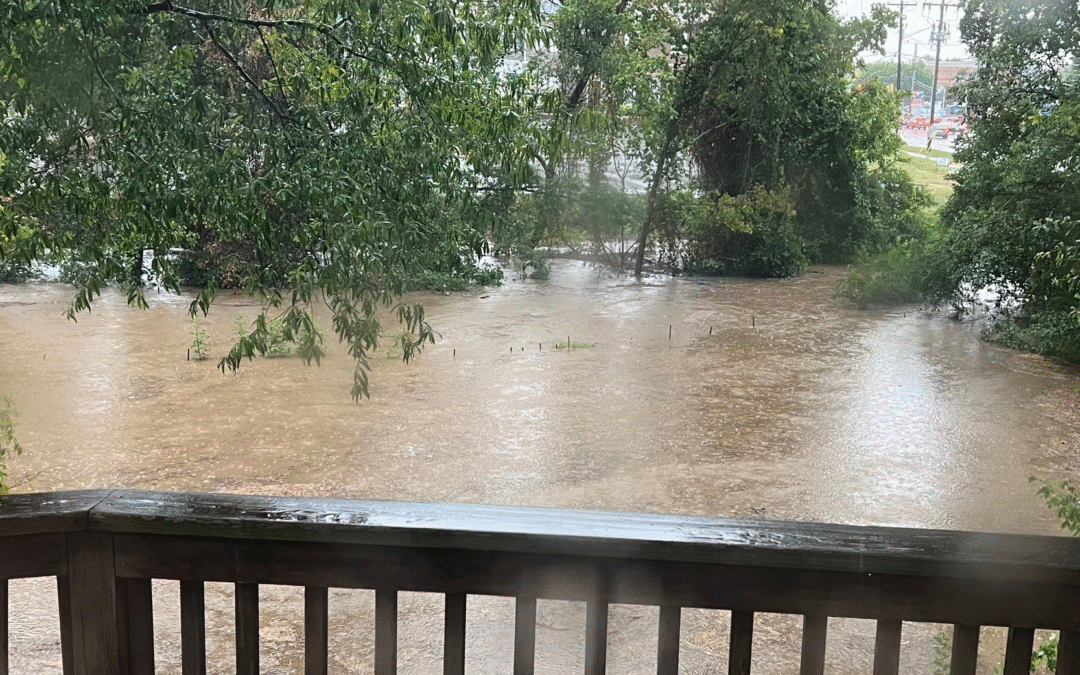
The “streamside option” is not “little used private pieces of land”. This land is our private backyards, where our children play. The greenway would be within 50 feet of our homes, decks, patios and private living spaces, and even closer to children play areas. For over 35 years, homeowners have maintained their landscaped backyards and preserved the integrity of Big Branch Creek at no expense to the City. With the recent 2024 sewer replacement project, numerous trees and vegetation were removed. And as a result, we have seen increased flooding and erosion in our backyards. If an impervious greenway were added 7 to 25 ft from the streambank as proposed, flooding and erosion will only become worse.
The City emphasizes concerns about stormwater runoff and environmental damage due to impervious surfaces, yet ignores those same concerns when it involves our neighborhood. Stewardship of the environment should not be selective or arbitrary.
The problem with frequent flooding on a greenway is the maintenance and repairs that will be ongoing and costly for the City. Frequent flooding will require costly ongoing maintenance, repairs, replacement and inspections for a ramp, bridges, safety rails and privacy fences. Flooding can take days to recede, causing extended greenway closure. Muddy greenways pose dangers to the walking and biking public. Major weather events have caused extensive damage to existing greenways near waterways in floodplains. For example, the City had to replace bridges that had been blown out after Hurricane Matthew (2016) and Florence (2018). Various areas had costly repairs and even replacement. One bridge remained closed for 4 years. Watch this WRAL video which validates this claim: Heavy rain causes flooding along greenways.
The Anderson Forest greenway route would be within Zone 1 of a Riparian Buffer, which is 30 ft from the stream bank and should remain “undisturbed forest vegetation” according to the NC Dept of Environmental Quality. Riparian Buffers prevent erosion, reduce flooding, and filter pollutants. Neuse River Basin administrative rules state that paved greenways “shall be located outside Zone 1 [Riparian Buffers] unless there is no practical alternative”. 15A NCAC 02B .0714.
This proposed greenway path does not meet Capital Area Greenway objectives. There will be very little “natural” area because the path is so close to the creek on one side and homes on the other. And an impervious greenway within 7 to 25 ft of the streambank will not protect the land or waterway. Rather, it will cause harm.
Existing greenways have experienced alarming incidents of assault, indecent exposure, and even murder in recent years. The entry to this proposed greenway is on a busy Six Forks Rd with 24 hour traffic that will provide easy criminal access to Anderson Forest homes along an UNLIT corridor. Watch this recent WRAL video as an example: Runners uneasy after string of sexual assaults, indecent exposures in Raleigh
Many residents from both neighborhoods agree that there are many compelling reasons why a greenway should not go through either of our neighborhoods. Let’s join together in solidarity to oppose all three routes and request that the City go back to the drawing board to find better options. This greenway will be a “greenway to nowhere” for many years until the multi-modal bridge is built to cross the beltline. Therefore, the City has time to re-evaluate. One suggestion is to coordinate the planning of a connector with the planning of the Waterfront district that will be located between Industrial Drive and Atlantic Ave near Crabtree Creek.
CRASH RATE DATA

If you appreciate the kind of reporting we bring to you
|
Please donate $10 or $20, Thanks for supporting |
 |