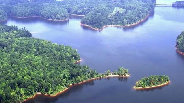
A zoning case to add density in the protected Falls Lake Watershed, an area with little to no access to public transit, threatens the safety of Raleigh’s drinking water.

Bob Mulder, a former chair of Raleigh’s Planning Commission, sent the following warning to the City Council:
February 13, 2022
To: Raleigh City Council
Re: Z-21-21, 8916 Six Forks Rd
There were two attempts to rezone this property in the past, Here are brief synopses of those requests. Accompanying this letter is a document entitled “Nibbling Away at the Watersheds” written and compiled in 2006 that has additional information about rezoning requests that were attempted in the Falls Lake Watershed from 1990 to 2006.
There are a number of reasons that this rezoning request should not be approved. The most important one is that it is in the Falls Lake Watershed. Allowing higher densities even with stormwater controls in the Falls Lake Watershed will set an extremely bad precedent for cases that will be similar to this one.
I am certain that some of the reasons given for this request are that it is next to a busy corridor that will have transit, and that since it is on a busy corner the value of the land does not make it suitable for low density development under the current R-1 zoning category. Both arguments are incorrect. The land can be developed under the current zoning just like other large lot developments that have been developed in the Falls Lake Watershed.
Stormwater detention facilities are useful and necessary in non watershed protection overlay district to help protect our downstream neighbors. These stormwater facilities require regular maintenance and inspections. The best and only way to protect water quality are by large lots that have undisturbed areas that do a better job of filtering water than engineered stormwater devices. Large lot developments are not perfect, but they are better than a densely developed watershed with stormwater devices.
If you approve this rezoning request you will be undoing what previous councils and citizens have worked hard to prevent, and that is incrementally allowing higher densities in the Falls Lake Watershed that the City of Raleigh is supposed to be protecting. If I am not mistaken, the City of Raleigh and Wake County purchased land in Granville County that protects streams that are flowing into Falls Lake. If you allow higher densities in the Falls Lake Watershed, you will be undercutting the City of Raleigh efforts to protect water quality. Here is a link to an article entitled “Why Raleigh and Wake County are helping to buy hundreds of acres in Granville County”.
Read more at: Why Raleigh and Wake County are helping to buy hundreds of acres in Granville County
If you, the current City Council, approve this zoning case, it will simply open the door to similar requests. As water quality declines, taxpayers will have to pay for increasingly more expensive water filtration strategies and facilities. This would not be a good legacy to leave behind.
While the City of Raleigh only has jurisdiction over a smaller area as compared to other municipalities, other cities and towns will be watching what you are doing.
You might think that this request is only a small compromise, but in the end, small compromises over a long period of time will result in compromisng away our water quality.
Please deny this zoning request.
If you have any thoughts or comments on my comments, you are welcome to call me at 919-215-1448 to discuss further this zoning request.
Sincerely,
Bob Mulder, Former Chair Raleigh Planning Commission
Nibbling Away at The Watersheds
What distinguishes good from bad development? Good development should be compatible with its area and add value, not only to the property being developed, but potentially to its neighbors as well. On the other hand, if development adds value to one property but does so at a cost to its neighbors, it is sort of legalized stealing and must be considered bad development. When developing in a water supply watershed, the concept of who is a neighbor must be broadened to include everyone in the community who depends on that water supply.
This concept is well understood by Wake County Commissioners and Raleigh City Councilors who regularly make decisions involving development in our watersheds.
The Watershed Protection Council and its members have been involved with dozens of watershed development issues over the years. Following are summaries extracted from WPC archives from 1990 to present. These cases include rezoning petitions, special use permits, text changes, ordinance changes, presentations, and participation in task forces and committees. The main focus of WPC has been the Falls Lake watershed, and jurisdictions have included City of Raleigh, Wake County, Town of Wake Forest, Durham County and State of North Carolina. These summaries are color coded as follows: green where the watershed was protected and red where development interests prevailed.
Archives of the Watershed Protection Council
Nov 1990 – ZP653, ZP654 Harvest Plaza/Alta Winds Rezoning Cases
May 1991 – Z-11-91, Z-12-91, Z-13-91
Several contiguous properties with different ownership were involved. Initial petition was for the county to rezone from R40W to General Business that portion of properties south of the ridge line. After Wake County approved this rezoning, the petitioners applied to Raleigh for annexation and Shopping Center and O&I zoning. Before this case, the watershed boundary was Strickland Road. This case set the precedent for using the natural ridge line to define the watershed boundary.
Aug 1991 – Feb 1992 NC EMC Watershed Classification
Acting on direction from the legislature, the NC Environmental Management Commission undertook a statewide classification of watersheds to insure all the state’s water supplies were protected. Public hearings were held throughout the state and heavily attended. Raleigh and Wake County officials and environmental groups pushed hard for a WS3 classification for Falls Lake watershed, which would have corresponded closely to existing city and county zoning ordinances. The final result was a WS4 classification which allows higher development densities than the City and County rules. The rationale given was that WS4 was a lowest common denominator, and local governments may always impose stricter rules. The result, however, is that the looser WS4 standard is always cited by developers when petitioning for higher densities in the watershed.
Nov 1992 – BA1514 Dry Cleaner Special Use Permit
Owner of property at corner of Six Forks and Durant Roads wanted to build a dry cleaner pick up and drop off store (no cleaning on premises). This was denied by the Wake County Board of Adjustment.
Sep 1994 – Z-47-94, Z-48-94 Wilson, Barbour Rezoning Cases
Two adjacent properties in the northeast quadrant of the Six Forks/Strickland Roads intersection were proposed to be rezoned to Office & Institutional. Though recommended for approval by the Raleigh Planning Commission, these cases were finally denied by City Council. The Barbour tract was later developed at low density residential and a church.
Oct 1994 – SU-21-94 Alta Winds Special Use Permit
The westernmost property in the 1990 Harvest Plaza rezoning case had been approved for O&I zoning at an allowed residential density of 10 units per acre. This special use request was to allow increased density to 15 units per acre. This property was south of the ridge line. This permit was approved by City Council. Alta Winds apartments were built on this site at the edge of the watershed.
Dec 1994 – Z-81-94 Gipson Rezoning Case
Property was located on the west side of Six Forks Road, just south of the I-540 Interstate (planned at time of this case). About 30 acres, the petitioner requested annexation by Raleigh and R4 zoning (four homes per acre). His silly argument was that neighboring CP&L tract would never be developed beyond the existing substation, and averaging the two would permit higher density on his property. This Rezoning case was denied by City Council.
Aug 1995 Cadmus Group Falls Lake Watershed Study
Study was commissioned by NC DEHNR to compile existing studies, model pollutant loadings and hydraulic flow, assess toxic spill risks and propose management options. Study recommended a regional approach to rulemaking to protect the lake in the future. Recommendations were broad and very general. Very little useful came of it.
Jul 1996 – Z-60-96 Wilson Rezoning Case, Second Try
Same property as in Z-47-94. Second attempt to rezone this property for O&I use. Raleigh City Council again denied this petition.
Jul 1996 – BA 1630 Gas Station Special Use Permit
Property on east side of Six Forks Road north of Norwood Road. This permit was approved by the Wake Board of Adjustment. Convenience stores with gasoline were then an approved special use in R40W zoning districts.
Nov 1996 – Z-116-96 Harvest Plaza Extension
About two acres of property north of the original ridge line defining the shopping center as approved in 1990. Before requesting this rezoning, the property owner bulldozed this area, moving the ridge line as far north as he could. Raleigh City Council approved this rezoning, but established a policy not to allow ridge line regrading in future cases that would move land from one watershed to another.
Mar 1997 – ZP718 Shriners Rezoning Proposal
Property on the west side of Creedmoor Road about a half mile north of Norwood Road. Fourteen acres at R40W zoning was proposed by the Amran Shriners to be rezoned half for O&I and half for General Business (shopping center). Property was completely surrounded by residential, with no other business uses between it and a convenience store at Norwood Road. Besides being spot zoning, this case was notable because a high Amran official was brother-in-law of a County Commissioner who strongly supported the proposal. In the end, Wake Commissioners denied this petition. Out of this case, many concerned citizens came together and the Watershed Protection Council was formalized.
Jun 1997 – OA97/10 Nonconformities Rule Change
This proposal was initiated when neighbors learned that Goldstons (a business on Hwy 98 that predated the creation of Falls Lake) had been allowed to expand in the watershed by adding a concrete plant. In most jurisdictions, a use grandfathered under old rules (a nonconformity) is allowed to continue, but may not expand and, if destroyed, may not be rebuilt except under the new rules. Wake County rules did not follow this practice. This was a rare case where citizens did not just react to an undesireable development, but proactively demanded the rules be changed. The Wake County Commissioners approved this rule change, applying the change not just to the watershed, as some had proposed, but to the entire county. Goldstons cement plant was grandfathered for this rule change.
May – Sep 1997 Wake County Land Use Plan
Recognizing the rapid population growth in the County, Wake Planning Staff had undertaken (starting in 1994) writing a new Land Use Plan addressing growth patterns, water, sewer, transportation and other infrastructure needs. The thrust of this plan was to encourage growth outward from existing municipal boundaries where water, sewer and other infrastructure could be expanded most efficiently. This plan met great opposition from property owners in outlying areas of the county (mostly farmers) who wanted the county to actively support growth into their areas so they could realize the greatest value from their land. Rhetoric became nasty, including death threats to the Planning Director. In the end, the original concept was gutted and the final result was a large document that provided neither vision nor strong guidance. Controversial stuff was included as position papers in Appendix A where they would not be binding on anyone. Strong protection for water supply watersheds did largely survive the gutting, however.
Oct 1996 – Aug 1997 LPPS Fiasco
Low Pressure Piping Systems for septic leach fields had been developed at NCSU and successfully tested in the sandy soils of eastern North Carolina. In the 1980’s, they were approved by NC DEHNR for use throughout North Carolina, and developers began using community wide LPPS to provide septic service for lots that were otherwise not buildable because they did not “perc”. By the mid-1990’s, more than 500 homes and several schools scattered throughout Falls Lake watershed were served by LPPS. It was not then recognized that LPPS did not work well in the clay soils of the Piedmont, that some of the systems had been improperly installed, and that the small utility companies set up to manage them were mostly not maintaining them. When Hurricane Fran hit in September 1996, trees fell in the LPPS fields, ripping up pipes. Suddenly, every LPPS system in the county had failed, leaving hundreds of homeowners and the affected schools without sewer service. At a cost of many millions of dollars, emergency sewer lines were run to connect the schools and all isolated groupings of LPPS homes to Raleigh’s sewer system. These costs were shared by the individual homeowners affected and by Raleigh, Wake County and the State. Using LPPS to bypass soil “perc” requirements had put the watershed at serious risk.
Jan 1997 – ZP728 Leesville/Strickland Roads Shopping Center
Property was 21 acres located at intersection of Leesville and Strickland Roads and just south of the then planned Leesville Road/I540 intersection. The ridge line ran across this property with 10.2 acres in the Falls Lake watershed. Because Wake County had no policy against regrading ridge lines, the first thing this developer did was a massive regrading to build up the back part of the tract so stormwater from most of the lot would flow south. His rezoning petition to change R40W and R40 zoning to General Business zoning was approved by Wake Commissioners. Once he got the Wake County zoning approved, he applied for and received annexation to City of Raleigh at the equivalent Raleigh Shopping Center Zoning. In this way, Raleigh’s rule against ridge line regrading was bypassed.
Aug 1997 – BA1730 Reopen and Expand Flower Shop
Property on the west side of Six Forks Road near Norwood Road. Business had not been operational for a number of years. New owner wanted to reopen and expand the store. This was not allowed under new nonconformities law and the Wake Board of Adjustment rejected this petition.
Sep 1997 – ZP681 R40W to R80W Rezoning in Falls Lake WS
Based on studies initiated four years earlier, Wake Planning Staff recommended moving the boundary between critical watershed (R80W) zoning and noncritical (R40W) to correspond to a 200 minute time of travel criterion. Proposal was to rezone 1790 acres in the Falls Lake watershed from R40W to R80W, although 80% of that land had already been developed to the R40W standard. This rezoning proposal was approved by Wake Commissioners.
Sep 1997 Durham Watershed Regulations
Durham County loosened its restrictions on development in four of its water supply watersheds. In Durham’s 12,000 acre critical portion of Falls Lake watershed, the changes allow “small scale” commercial development (convenience stores, restaurants, offices). “Large” shopping centers and industrial uses were still disallowed, except for 500 acres around Treyburn where “light Industrial” was allowed. The changes also allowed more clustered residential and exempted stream buffer requirements in some situations.
Sep 1997 – Jun 1998 “Remember Lake Raleigh”
This presentation, prepared by WPC member Vern Budinger, reviewed the eutrophication of lakes and how the process is accelerated by surrounding development. 75 acre Lake Raleigh, located in the southern portion of what is now NCSU’s Centennial Campus, was Raleigh’s sole water supply from 1900 until 1927, and continued as an auxiliary source until 1986. In 1992, NC DEHNR declared Lake Raleigh’s water to be non-potable due to accumulated pollutants. Hurricane Fran blew out the dam in 1996. On walking the empty lake bed afterward, it was shocking to see how much silt had washed into the lake and built up on the lake bottom. Lake Raleigh is a small but graphic reminder of how surrounding impervious surface causes excess stormwater flows that eventually make a lake useless for water supply purposes. This presentation was never presented in full form, but a highlight version was incorporated into arguments before City Council against rezoning case Z-102-97 (see below).
Dec 1997 Six Forks/Strickland Small Area Plan
City of Raleigh periodically develops small area plans for areas undergoing rapid change. These plans are developed by a task force of area residents and concerned citizens and are intended to guide City Council and the Planning Staff in future rezoning and development proposals. Six Forks/Strickland is designated a City Focus Area, normally shown on maps as a large circle centered at the road intersection. Developers tried to interpret these maps literally to mean that commercial development is allowed anywhere in the big circle. In this case, however, the top half of the big circle is in the watershed and off limits to commercial development. Both development interests and watershed protection interests participated in the task force. In the end, sanity prevailed and the final plan continued the ban on commercial development north of the watershed ridge line.
Dec 1997 – RZ-97-14 Wake Forest Rezoning Case
Property was forty acres south of Hwy 98. Petition was to annex the property and rezone from a mix of R40W and R80W to Office and Institutional. This was the first of several cases after Wake Forest lost its contest with Raleigh to annex the Wakefield land. Wake Forest commissioners were determined not to lose any more annexation battles and gave developers everything they asked. Despite appeals to better protect the watershed, this case was approved.
Apr 1998 Wake Water/Sewer Task Force
This task force of interested parties and concerned citizens came together under guidance of a consultant to craft a growth plan for water and sewer services in Wake County. During many meetings, the agendas of developers who wanted water and sewer services to be provided wherever they had land to develop, and the environmental community who wanted to preserve open space and inhibit growth in environmentally sensitive areas like water supply watersheds, conflicted. The final proposal was crafted to provide something for everybody, but did not recommend providing water and sewer service in the water supply watersheds.
May 1998 – Z-53-97 & Z-102-97 Wachovia Rezoning Case
Property was 79 acres north of Strickland Road between Wentworth Park and Heritage Point subdivisions and held in trust by Wachovia Bank. The ridge line ran across the property with about eight acres out of the Falls Lake watershed. Proposal was to massively regrade the ridge line to move an additional nine acres out of the water supply watershed and to rezone the resulting 17 acres for R4 development (four homes per acre). The portion north of the new ridge line would be developed at RR zoning (one home per acre). Honoring its policy against ridge line regrading, City Council denied this petition. This entire property was later developed as Traemoor, a luxury community with one acre lots (even on the eight acres south of the ridge line that could have been developed at four homes per acre).
Jun 1998 Open Space Advisory Committee
This task force was formed in June 1997 by interested parties and concerned citizens to make recommendations to the Wake Commissioners regarding open space preservation. The immediate recommendation for a full-time staff position dedicated to open space was approved, but the recommendation to budget $1 million the following year for open space acquisition was turned down. However, the idea of preserving open space resonated with citizens and this task force became a permanent advisory committee in December 1998. Voters passed bond issues of $15 million in 2000 and $26 million in 2004 to support open space land acquisition. Open space preservation is now a priority in Wake County.
Jul 1998 – RZ-98-11 Wake Forest Rezoning Case
Property was 125 acres south of town between Capital Blvd and the Neuse River. Petition was to annex the property and rezone from R30W to a mix of R10, O&I and Highway Business. This property was not in the water supply watershed, but in sensitive area feeding stormwater into the Neuse River. This case was approved and is another example of how competition for annexation led to unwise development.
Nov 1998 – Z-766-98 Durant/Honeycutt Rezoning Proposal
Property was 80 acres in the NE quadrant of the Durant Road, Honeycutt Road intersection. This area had been changed from R40W to R80W by ZP681, and was now proposed to be changed back to R40W. It was interesting that this proposal was not initiated by the landowner, but by a Wake Commissioner on behalf of the Board of Commissioners. Proposed use for the land was never specified, although possibilities of a church and a school were mentioned. Following questions of procedure, this proposal was withdrawn.
Dec 1998 – Feb 1999 – BA1802 Gas Station Special Use Permit
Property was in the SW quadrant of Norwood and Creedmoor Roads. Two gas stations had recently been built or enlarged in the NE and SE quadrants and many citizens objected to this third station. The Board of Adjustment initially denied this request. In Feb 1999, the petitioner came back to the Board for reconsideration. The Board of Adjustment then reversed itself and approved this special use permit, resulting in the three gas stations now at this intersection. The Board of Adjustment followed the letter of the law in this case. This case set in motion an initiative by WPC to get the law changed (see below).
Feb 1999 – Z-9-99 Walton Rezoning Case
Property was a five acre tract located on the west side of Falls of Neuse Road, north of Honeycutt Road. Three acres were east of the ridge line and not in the watershed; the other two acres were in the Falls Lake watershed. Proposal was to rezone all five acres to O&I for construction of offices or a hotel. The watershed portion of the lot would have been used for parking. In the end, the developer modified his petition to include only the three acres outside the watershed and this was approved by City Council. The two acres in the watershed remained at low density residential zoning.
Feb 1999 – May 2001 – Z-12-99 Ferbytown Rezoning Case
Property was 13 acres in the SW quadrant of Creedmoor and Strickland Roads, extending in an “L” shape behind existing businesses on the corner, and with frontage on both Strickland and Creedmoor Roads. The petition was to rezone from R4 Residential to Office and Institutional. This area was not considered in the watershed because it was south of Strickland Road, the original boundary for Falls Lake watershed. But, as the case unfolded, it was learned that the ridge line dipped south of Strickland Road in this area, and part of the property actually drained north into Falls Lake. Because of the many prior cases setting precedent that the natural ridge line should determine the boundary of the watershed, it seemed right for that rule to apply to this property. Of course, the petitioner did not agree and a protracted battle ensued. Sensing that he did not have the votes on City Council to win, the petitioner was able to have this case referred to the Council’s Comprehensive Planning Committee. That Committee’s chair, in an unprecedented strategy, kept this case off its agenda for two years! During that time, members of City Council changed and, when it was finally moved back to City Council in April 2001, it was approved.
May 1999 I540/Falls of Neuse Small Area Plan
This small area plan was initiated to guide future development along Falls of Neuse Road between Honeycutt Road and the future intersection with I540. As with all such efforts, a task force was formed from interested parties (developers) and area residents. The resulting plan recognized that there was no road widening scheduled for this stretch of Falls of Neuse Road and recommended transitional low density commercial development (O&I) on the east side, and no commercial development in the watershed protected areas on the west side of Falls of Neuse.
Apr 1999 – Jan 2000 – BA-1822 Ray Special Use Permit
Property was 2.3 acres at the intersection of New Light Road and Old Weaver Trail. Petition was for a special use permit to build a convenience store/gas station within the Falls Lake watershed (R40W zoning). The law allows such a special use if it is within a designated neighborhood activity center, but the nearest one was 3/4 miles away. Despite Wake Staff’s testimony that the petition did not meet the requirements of the law, the
Board of Adjustment approved this petition, basing its decision on there being no definition in the law of the size of an activity center. This set off an unprecedented action by the Wake Board of Commissioners to appeal its own Board of Adjustment’s decision in Superior Court. The Commissioners won the appeal and the Board of Adjustment had to rescind this special use permit. The petitioner then requested the designated activity center be moved to his site. By the time this request was granted, the Commissioners had changed the law to ban gas stations in the water supply watershed (see below), and this convenience store/gas station was never built.
Jan – Aug 2000 Ordinance Amendment – Gas Stations in WS
After a number of new gas stations were approved within the watershed (see above), WPC petitioned the Wake Commissioners to change the zoning ordinance to eliminate sale of gasoline as a permitted special use within water supply watersheds. Staff required WPC to show solid scientific justification for this proposal. WPC prepared position papers showing the number of gas stations already in Falls Lake watershed and those recently added or expanded, and demonstrating the small but real risks of leakage from underground storage tanks. There had been enough cases of tank leakage in Wake County to show that this risk was real. In the end, Wake Commissioners approved this ordinance change, closing the door on more new gas stations going into Wake’s water supply watersheds. Convenience stores without gasoline sales continue to be an allowed special use.
Aug 2000 Peninsula Park Marina
Peninsula Park was planned on land donated to Raleigh by the developers of Wakefield. It is a 400 acre park on a peninsula jutting into Falls Lake near Old Hwy 98. When initial plans were made public, a 150 slip marina was included. This raised concern that such a marina would greatly increase the number of power boats on the lake and the attendant risks of fuel spills directly into Raleigh’s water supply. People also saw it as a perk for the wealthy homeowners of Wakefield. After much public debate, the marina was removed from the park’s plan. Plans for this park are moving forward without a marina (at this writing).
Sep – Nov 2000 Dry Boat Storage
Three owners of land off Six Forks Road near Falls Lake were cited for operating illegal businesses in the Falls Lake watershed – dry boat storage for boat owners who did not want to haul their boats to their homes (many subdivision covenants do not allow storing boats outside homes). Two of these businesses closed immediately, but the third appealed his citation, first to the Wake Board of Adjustment, which denied him. Then he petitioned the Wake Commissioners for an ordinance change. In the end, this appeal was denied and he too had to close his dry boat storage business.
Sep – Nov 2001 – TC-10-01 Master Plan Exemptions
A new state rule for controlling nitrogen in stormwater had been introduced. This Raleigh text change granted a four year exemption for meeting this rule to master plan developments (large projects completed in stages) that were at least 50% completed. Master plan developments less than 50% completed were granted a two year exemption. This text change was proposed and drafted by a developer’s attorney. It was approved in a contentious session by a lame duck Mayor and several lame duck City Council members, ignoring a request to defer the decision to the incoming City Council.
Jan – Jul 2002 – TC-3-02 Impervious Surface Transfer Right
North Raleigh United Methodist Church’s facilities on the west side of Honeycutt Road north of Falls of Neuse Road were already Raleigh’s legal limit of 30% impervious surface for the Falls Lake watershed. They wanted to expand further. They proposed text change TC-3-02 that would allow impervious surface transfer rights from a noncontiguous property somewhere else in the same watershed that the church would buy and commit not to develop. Such a rule would have created an enormous loophole, allowing any nonresidential use in the watershed to increase impervious surface just by buying an inexpensive, nearly undevelopable property somewhere else, and commit not to develop it. This text change was denied by City Council. The church eventually got a variance for its expansion plan, and are now completing construction of a new sanctuary with total impervious surface at 50%.
Jan – Nov 2002 Watershed Management Task Force
A consultant led stakeholders group was convened to establish guidelines for future development within Wake’s water supply watersheds. The resulting comprehensive watershed management plan recommended no development in the 100 year flood plain, wider stream buffers, and that effort should be made to minimize imperiousness. However, no agreement was reached on setting specific numerical limits on impervious surface – only soft words on how nice it would be to limit it.
Jun 2002 Providence Baptist Church
Property was 73 acres north of Strickland Road between Baileywick and Ray Roads. Providence Baptist, a 6000 member mega-church located in a converted hotel on Glenwood Avenue was considering this site for an enormous new (400,000 sq.ft.) church, school and meeting complex. Even though the site was large, many trees would be sacrificed for buildings, parking and sports fields. Impervious surface would be 29%. Following discussions with church leaders and strong resistance by neighbors, the Church withdrew this proposal.
Sep 2002 – May (?) 2006 Unified Development Ordinance (UDO)
Wake Planning Staff decided in 2002 that the County’s ordinances had evolved to a level of complexity that was difficult to administer, and should be streamlined, simplified and modernized. A consultant was hired and the process of rewriting the entire county ordinance from A to Z was started. Stakeholders meetings were held to identify areas of dissatisfaction with current code, but the basic goal of the UDO project was to rewrite the ordinance for clarity and organization only, without fundamentally changing content. In August 2003, the consultant presented an outline of the new UDO with a timetable for completion by mid-2004. Of course, the goal of rewriting the entire code without making content changes was doomed from the start. A UDO Committee was formed that was dominated by builders and developers. This committee met frequently and a series of content amendments were put forward and processed through the Planning Board for Commissioner approval. WPC participated in one such effort for an “Open Space Subdivision” amendment (clustered homes with large open spaces preserved) that was approved in early 2005. The UDO has now grown to more than 360 pages and there are sections still not completed. It has been impossible for WPC to keep up with all the changes and, at this writing, we simply do not know if there are provisions in this new code that will put the water supply watersheds at risk.
Jan-2004 Sheaffer Systems
Planned Ridgley Hills and Rockbridge subdivisions in Knightdale were proposed with a community-wide sewage system based on a concept that had never been used in North Carolina. Sheaffer systems feed raw sewage into the bottom of a deep, open pond where it undergoes a natural breakdown by microbes over a period of 3-4 weeks. During processing, raw sewage and solids are supposed to stay at the bottom of this first pond with clear effluent flowing off the top into a holding pond. From there, it is sprayed onto lawns and other landscape features. While the Sheaffer system has been used in other states, it has not undergone lifetime tests in NC soils and under NC climate and rainfall conditions. Although this case was not in a water supply watershed, concerns were that once one Sheaffer system was approved for Wake county, others would follow. Given the LPPS fiasco (see above), it did not seem wise to introduce another experimental sewage system. The Wake commissioners rejected the Sheaffer system for these subdivisions, and it was expressly banned in the new UDO.
Jun – Nov 2004 Residential Impervious Surface in WS
One concern raised in the early UDO stakeholder meetings was the lack of zoning specific impervious surface limits for residential uses in water supply watersheds. When current zoning ordinances were written in the 1980’s, a typical residence created about 5000 sq.ft. of impervious surface (rooftop, driveway, walks, etc.). Minimum lot sizes of 80,000 sq.ft. for R80W and 40,000 sq.ft. for R40W were mandated that, in theory, would result in approximately 6% and 12% impervious surface in these zoning districts. However, impervious surface limits were not part of the code (except a default 30% limit that applies across all of Wake County). Starting in the 1990’s, the watersheds became a magnet for subdivisions of luxury homes. Not only were rooftops larger, but many paved amenities such as circular drives, large parking areas, patios and swimming pools became common. Some of these residences generated impervious surface of 15,000-20,000 sq.ft. and more. When it became evident the UDO Committee would not take on this issue as an amendment to the new UDO, WPC raised it directly to the Commissioners in a November, 2004 presentation. It was then referred to a recently created Stormwater Management Committee, which WPC joined as a stakeholder (see below).
Sep – Nov 2004 Butner Nitrogen Transfer Proposal
Butner is a town managed by NC Department of Health and Human Services which coincidently includes the Division of Water Quality. With a new mental hospital planned, there was need to increase Butner’s sewage processing capacity. Butner’s sewage disposal plant discharges into a feeder stream of Falls Lake, and was near its nitrogen discharge limit. Rather than invest in new equipment to reduce the nitrogen in the plant’s discharge, NCHSS came up with a plan to buy nitrogen credits from a facility in the New Bern area that was closing, and transfer them 200 miles upstream to Butner. Worse yet, their attenuation formula allowed them to buy 6000 lbs. of nitrogen credits in New Bern to offset 60,000 lbs. put into the stream in Butner! NCHSS tried to get their permit from Division of Water Quality without public notice. Word got out, forcing two public hearings. (The first one was in a small room in Butner that could not accommodate the crowd that came, and a second hearing was forced in a larger Raleigh facility). The resulting publicity, the obvious conflict of interest between Division of Water Quality and NCHSS, and great turnout by the Neuse River Foundation and other environmental groups eventually forced NCHSS to retreat from this proposal.
Nov 2004 – ZP-844-04 ABC Store Rezoning Proposal
Property was 3.6 acres in the NE corner of Baileywick and Creedmoor Roads, bordered to the rear by the I-540 eastbound on-ramp. The Alcohol Control Board wanted to build a new ABC store on this site to replace a smaller existing store several miles to the south on Creedmoor Road. The Alcohol Control Board chairman was a former Wake County Commissioner. Initially, the Board tried a text change (OA 04/04) that would add neighborhood indoor retail and service trade establishments as an approved special use within R40W watershed zoning districts. When it became clear that this text change was not supported by Wake Staff, this proposal was withdrawn and rezoning of the property was requested. Despite massive neighborhood resistance, the Wake Planning Board recommended approval. The Commissioners, however, saw it differently and denied this petition.
Jan 2005 – Feb 2006 Stormwater Management Committee
This committee was initially formed in late 2004 to address homebuilder problems in meeting the Neuse River rules imposed by the State in 2001. Wake Staff had established a 15% impervious surface limit as the most practical way of meeting the Neuse River rules, and builders were finding 15% too hard to meet. WPC joined this committee with a position that 15% was not tight enough for the watersheds – that 6% and 12% were the appropriate levels for R80W and R40W respectively (see Residential Impervious Surface in the WS, above). This committee met for more than a year under guidance of a consultant, trying to reach consensus within a highly polarized group. In the end, the Committee recommended changing the yardstick from percent impervious surface to curve number, agreed on a set of curve number targets that are lower for larger lots (R80) and higher for smaller lots (R30), and a toolbox of low impact development (LID) practices to help builders meet these curve number targets at least cost. The curve number targets are set at levels described by the consultant as “strong medicine”. Where these curve numbers cannot be met by LID practices, volume control ponds will be required to capture and slowly release the first three inches of rainfall. Assuming these recommendations are incorporated into the UDO without fundamental changes, stormwater controls will be markedly improved in all parts of the county’s jurisdiction.
Feb 2006 – Z-12-2006 Harvest Plaza Second Extension
Property was 1/3 acre east of Harvest Oaks Drive, south of the closed section of Baileywick Road and north of the previously approved extension of Harvest Plaza (Z-116- 96, see above). Petitioner requested rezoning from Rural Residential to Shopping Center. This remnant was formed by the connection of Harvest Oaks Drive with Baileywick Road and the closing of a section of Baileywick Road between this parcel and the YMCA. Through an administrative error, the watershed protection overlay had not been applied to this remnant when the area was annexed by Raleigh. This error was corrected after the case was filed, leaving the proposal inconsistent with the City’s comprehensive plan. Petition was denied by City Council.
Other Issues as We Move Forward
Churches in the Watersheds
Churches are an allowed special use in water supply watersheds, in both Wake County and City of Raleigh jurisdictions. In Wake R80W zoning, churches are limited to 6% impervious surface. In Wake R40W zoning, churches are limited to 12% impervious surface, but may go up to 24% if they detain a small amount of initial rainfall. In the City jurisdictions, churches may go up to 30% impervious surface with modest stormwater detention. In both jurisdictions, storm water detention standards are not up to what is today believed necessary for good stormwater management.
If churches in the watershed were limited to scattered local congregations, the relatively large impervious surfaces generated by them probably would not be an issue. But many new churches are being drawn into the water supply watershed by the availability and relatively low cost of large tracts of land. Some of these churches are quite large and their congregations do not live principally in the watershed. Providence Baptist Church (see above) was a case in point. Following are examples of churches that have recently moved to new facilities in the watershed or enlarged existing facilities already in the watershed.
Wakeminister Baptist Church. Addition. August 12, 2003 BOA; SU-1984-03. Falls Lake watershed. New 3900 sq.ft. Sunday School addition to existing facility on 4.3 acres at Old Creedmoor Rd. and Hwy. 98. Sanctuary seating for 140 and 64 parking places in R40W zoning. Wake County Jurisdiction. New impervious surface is 23.7%.
Bay Leaf Baptist Church. New. September 9, 2003 BOA; SU-1987-03. Falls Lake Watershed. Large, brand new facility on 19 acres near intersection of Falls of Neuse Rd. and old Hwy. 98. Sanctuary seating for 800 and 239 parking places in R40W zoning. Wake County Jurisdiction. Impervious surface is 24%. This is a satellite church mainly to serve Wakefield residents.
McCullers Community Church. Reinstate. September 9, 2003 BOA; SU-1985-03. Swift Creek Watershed. Convert an existing building on one acre at 133 Rand Road (Garner LRUSA) to church use. Sanctuary seating for 72 and 14 parking places in R40W zoning. Facility was built as a church in 1975, converted to a school in 1994, closed in 1999 and now to reopen as a church with no expansion of the building. Wake County Jurisdiction. Impervious surface of 23.2% is unchanged by this action.
Penny Road Church of the Nazarene. Addition. September 9, 2003 BOA; SU-1986-03. Swift Creek Watershed. Add new 3500 sq.ft. Sunday School building to existing 14,700 sq.ft. facility on 6.4 acres at Penny Road and Huntford Lane. Sanctuary seating for 348 and 113 parking places in R40W zoning. Wake County Jurisdiction. New impervious surface is 23.8%.
New Community Church. New, under construction. December 9, 2003 BOA; SU-1996-13. Falls Lake watershed. New church facility on west side of Six Forks Road just north of I-540. 30,000 sq.ft. building, sanctuary seating for 600 and 153 parking spaces on 17.4 acres in R40W zoning. Wake County Jurisdiction. Impervious surface is 12.6%. Church members presently meet in theater south of Spring Forest Road.
North Raleigh Church of the Nazarene, Christ’s Sanctified Holy Church. Two churches built in early 90’s. Falls Lake watershed. Located on north side of Strickland Road, just east of Six Forks Road. City of Raleigh jurisdiction. Size and impervious surface unknown, but City allows up to 30% impervious surface with stormwater management devices.
Windbourn United Methodist Church. New, recently completed. Falls Lake watershed. Corner of Baileywick Road and Six Forks Road. City of Raleigh jurisdiction. Old Windbourn Methodist was many miles away on Millbrook Road. Size and impervious surface unknown, but City allows up to 30% impervious surface with stormwater management devices.
Growing Builder Influence and Fewer Community Activists
In recent years, developers and home builders have taken a much more active role in influencing local legislation. This is much in evidence in the membership of various committees, task forces and boards. To some extent, this is the result of the growing body of rules that are imposed on the building industry as the Triangle grows and becomes more sophisticated. It is also their perfectly legitimate exercise of citizen rights.
At the same time, it seems that the cadre of citizens who are concerned with issues of good development and are willing and able to spend the time and effort to attend meetings and sit on committees and boards is not keeping pace with the growth of the region. This is creating an imbalance of forces that control the way our area will develop, and will, inevitably, lead to increased risk of overdeveloping our water supply watersheds.
Finally, Looking Back
The following article appeared in the Wall Street Journal on December 11, 2002. It is an impressive reminder of how far and how quickly we have come in creating and managing our water resources. It truly provides perspective for us all as we work to protect our water resources for future generations.
DÉJÀ VU
By CYNTHIA CROSSEN
Before Home Spigots, Water Was Never Taken for Granted
AFTER TRYING OUT her new shower in 1799, a Philadelphia woman named Elizabeth Drinker noted in her diary that she had tolerated the new experience “better than expected, not having been wet all over at once for 28 years.”
Getting wet all over was once a luxury few people could afford. Until the early 20th century, using water, for most people, meant first locating and then hauling it. There were no taps, let alone water heaters, and since there were also no drains, what was brought into the house had to be taken out. Along with heat and food, water was a commodity most early Americans never took for granted.
On the Western plains where the author Wallace Stegner grew up, “You boiled sweet corn, say. Instead of throwing the water out, you washed the dishes in it. Then you strained it through a cloth into the radiator of your car, and if your car should break down, you didn’t just leave the water to evaporate in its gullet, but drained it out to water sweet peas,” he wrote in his book “Wolf Willow.”
Some Americans are becoming reacquainted with the idea that their faucets may not produce an infinite stream of clean water. Throughout this past summer, low rainfall forced water restrictions in several states.
THE AVERAGE AMERICAN uses between 50 and 100 gallons a day, depending on region and season. In 1900, the average person used five. Only 15% of households then had flushing toilets – now the biggest users of indoor water. Even fewer homes had bathtubs; for most people, bathing was a dreaded Saturday-night ritual involving a small tin tub and shared water that was either too hot or too cold.
Indeed, bathing was once considered by many to be unhealthy; in 1815, the city of Boston outlawed it unless it was done under a doctor’s orders. Not until 1919 did plumbers and soap makers start a Bath a Day marketing campaign that became wildly successful. One plumber, writing in Illinois Master Plumber magazine, even claimed bathtubs were useful in the fight against Bolshevism: Being clean, he opined, would make the lower classes feel better about themselves and less likely to rise up against authority. Even so, by 1950, only 64% of American homes had full bathrooms.
People always needed water for their gardens, but, as Mr. Stegner noted, they often used “gray water,” which they had saved from rinsed dishes, clothes or hands. Nor would people living in 1900 have lawns of Kentucky bluegrass, now one of Americans’ favorite turfs, which demands a steady diet of water in summer. They also wouldn’t have had swimming pools, water beds, washing machines, hot tubs, underground sprinklers, aquariums, misting fans, dishwashers or garbage disposals. They didn’t have cars to hose down, and no one was advising them to drink eight glasses of water a day.
For the urban poor a century ago, water was scarce, costly and dangerous. It could be bought by the bucket or barrel from water peddlers, but so-called tea water (pure enough to drink without boiling) was prohibitively expensive. Water might also be available at irregular times when street pumps or hydrants were operating. Because a tenement of 2,000 people might not have a single bathtub, many cities built public baths, the one place people could immerse their entire bodies.
IT WAS ONLY in the 20th century that people realized water not only quenched thirst and nourished crops, but also killed. Water-borne diseases like cholera, dysentery and typhoid were thought to be generated spontaneously from filth and spread by invisible gas or miasma. The real culprit was usually the proximity of wells to outhouses or the common practice of dumping sewage and trash into rivers, lakes and streams.
The first public water systems were built primarily for fighting fires and for manufacturing; households were considered secondary users. The water, usually untreated, was often unpalatable. Even so, with water both easy to get and cheap, consumption quickly started rising.
On farms, wells were dug by hand, excavating through rock until the water flowing in overtook the digger’s bailing rate. The well might be several hundred feet from the house. In the 19th century, it was calculated that a typical North Carolina housewife walked 148 miles a year carrying more than 36 tons of water. Doing the laundry was, as a Nevada housewife put it, “the Herculean task which women all dread.”
Washing and rinsing one load of laundry used about 50 gallons of water; a bucket held lessthan three gallons.
“Do you see how round-shouldered I am?” a rural Texas woman asked Robert Caro when he was reporting “The Path to Power,” a biography of Lyndon Johnson. He explains on his Web site: “She said, ‘I’m round-shouldered from hauling the water.’ Another woman said, ‘You know, I swore I would never be bent like my mother, and then I got married, and the first time I had to do the wash I knew I was going to look exactly like her by the time I was middle-aged.’ Americans now have some of the cleanest, cheapest and most reliable reservoirs in the world. Unlike their forebears, however, they will never truly appreciate the weight of water.
John Grace
Watershed Protection Council
March 6, 2006