
Attendees stand to oppose the plan
Wednesday evening, April 23, 6pm at NCSU’s McKimmon Center was the 1st Neighborhood Meeting for the proposed 30-story tower on West Street at Peace Street.
The meeting was attended by over 100 people.
This is the same proposal that was denied by the City Council in a 6-2 vote two years ago.
You may have read previous posts here and on social media saying that this proposal should be denied again because it violates 4 city plans, 47 city policies and 2 2030CP tables.
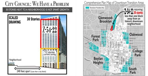
There is not one single city policy or plan that supports more than 12 stories at this location.
You might ask: What plans? What policies? What maps? With this blog we will start showing you the details of the analysis compiled by Raleigh Neighbors United (RNU).
Raleigh’s growth plans describe the right places to add density.
They all say this is the wrong place to add a 30 story building.
The neighbors support the current zoning for 12 stories.
12 stories is Density
Four City Plans
2030 Comprehensive Plan (2030CP)
The 2030 Comprehensive Plan (2030CP) is a long-range policy document adopted and amended by the City Council. The Plan establishes a vision for the City, provides policy guidance for growth and development through 2030. The 2030CP was adopted by the City Council on October 7, 2009, with an effective date of November 1, 2009. The 2030CP Update was adopted by six City Council resolutions in 2019.
Capital Blvd Corridor Study
The Capital Boulevard Corridor Study is an area plan companion to the Comprehensive Plan and was released in June of 2012 and amended in August. It presents an ambitious yet realistic vision for transforming the most-travelled and least-loved gateway into downtown Raleigh into a showcase. The plan development had substantial engagement in creation of development policies from citizens, Raleigh’s Department of City Planning serving as lead agency, assisted by an internal working group consisting of representatives from the Parks and Recreation department; the Stormwater Division of the Public Works department; and the Office of Transportation Planning.
Equitable Transit Oriented Development Guidebook
The Equitable Transit-Oriented Development Guidebook is companion to the Comprehensive Plan and was released in July of 2020 with the goal amongst others to provide insight into how much Raleigh should grow around the BRT corridors and strengthening Raleigh’s Comprehensive Plan to help Raleigh evolve into the thriving and resilient city it aspires to become. Development taking into account neighborhood context, transitions in density, height and scale along with buffering and mitigations are all written and illustrated clearly throughout the plan.
Raleigh Downtown Plan
The Raleigh Downtown Plan is an area plan companion to the Comprehensive Plan and was released in September of 2015 with a goal of providing guidance for downtown Raleigh for 10 years. The plan includes details of the new park and surrounding areas including the site covered in Z-54-22.
This blog will take a deep dive into the Comprehensive Plan. Future blogs will look at the other plans.
2030 Comprehensive Plan Analysis
The 2030 Comprehensive Plan (2030CP) provides strong guidance at the West Street location for 3 to 12 stories in height, protection for neighborhoods and historic resources through 47 different 2030CP policies, 9 which are Major, 3 core definitions, 2 tables and many other areas of text throughout the 2030CP.
The City of Raleigh spent 10 years, 1,000s of hours and 1,000,000s of dollars on this plan and there is no reason to abandon it. Note, if all of the already rezoned potential housing units were built, Raleigh will have well exceeded the desired add of 120,000 housing units. Funding for parks and programs cannot trump all plans, many policies, historic resources, neighborhoods, homes and families.
The full analysis of the 2030CP by Raleigh Neighbors United can be found here: Historic Glenwood-Brooklyn Neighborhood 2030 Comprehensive Plan analysis for Z-54-22
Excerpts from the analysis are as follows:
Policy DT 1.14 Downtown Transition Areas: In areas where the Downtown Section boundaries are located in proximity to established residential neighborhoods, residential densities should taper to be compatible with adjacent development. Nonresidential uses with the greatest impacts—such as theaters, concentrated destination nightlife and retail, and sports and entertainment uses—should be directed away from these transition areas.
Transitions Defined: Incompatibilities arise when nearby uses differ significantly in terms of intensity, height, and/or bulk.
Policy DT 1.12 Downtown Edges: is inconsistent with the request. That policy states, ‘Appropriate transitions in height, scale, and design should be provided between Central Business District land uses and adjacent residential districts.’
Do not be fooled by claims that the Historic Glenwood-Brooklyn Neighborhood (HGBN) is not “adjacent” to the proposed development because they don’t share a border.
The Comprehensive Plan does not define adjacent or abutting. The UDO also does not define adjacent or abutting. Per Sec. 12.1.1. General Meaning of Words and Terms A. All words and terms used have their commonly accepted and ordinary meaning unless they are specifically defined in this UDO or the context in which they are used clearly indicates to the contrary. The ordinary meaning of “adjacent” is nearby. The ordinary meaning of “abutting” is to border on. See a full analysis here: Analysis of HGBN being Adjacent to Z-54-22
Central Business District: Heights in the downtown could reach as high as 40 stories in the core, but would taper down to meet the adjacent neighborhoods at a height of three to four stories.
Policy LU 5.6 Buffering Requirements: adjacent to areas of lower intensity should provide effective physical buffers to avoid adverse effects. … transition zones … height and/or density step downs.
Policy HP 2.7 Mitigating Impacts on Historic Sites: Development proposals adjacent to or including historic sites should identify and minimize or mitigate any negative development impacts on those sites.
Policy UD 8.2 Transit Area Transitions: There should be a transition of use, intensity and scale from higher-density transit corridors to adjacent neighborhoods. Developments of greater bulk and height in areas should be located immediately surrounding transit stations. As distance from such stations increases, development should taper down in bulk and height in order to balance the needs of transit-supportive density with established neighborhood character.
Policy LU 5.7 Building Height Transitions: When a mixed-use or nonresidential area contemplated for building heights in excess of seven stories abuts an area designated for low or moderate density on the future land use map, building heights should not exceed a 45-degree plane starting 10 feet from the adjoining lower-density area. When any mixed-use or non-residential area is separated from an area of low-or moderate-density by an intervening street other than a Major Street, building faces along the frontage facing the residential area should not exceed three stories.
Policy UD 2.4 Transitions in Building Identity: Establish gradual transitions between large scale and small-scale development. The relationship can be improved by designing larger buildings to reduce their apparent size and recessing the upper floors of the building to relate to the lower scale of the adjacent properties planned for lower density.
Policy LU 7.4 Scale and Design of New Commercial Uses: New uses within commercial districts should be developed at a height, mass, scale, and design that is appropriate and compatible with surrounding areas.
Policy DT 1.16 High Density Development: Highest density development should occur along the axial streets (Hillsborough Street, Fayetteville Street and New Bern Avenue), major streets (as identified by the Street plan), surrounding the squares, and within close proximity to planned transit stations.
Table LU-2 recommended Heights: When a conflict exists between Edge and Core/Transit locations, such as when a small site is adjacent to both a transit corridor and a Low Density Residential area, the area will be considered a General area. The maximum height in a General area is 12 stories. 20-30 Stories Violates the Recommended Height Designations (Stories) from 3.1 Future Land Uses Heights in Mixed Land Use Categories Table LU-2.
30 Stories and Z-54-22 Violates Table UD-1 Design Guidelines for Mixed-use Developments: Mixed-use Areas: Transition to Surrounding Neighborhoods: 2. Within all mixed-use areas, buildings that are adjacent to lower density neighborhoods should transition (height, design, distance, and/or landscaping) to the lower heights or be comparable in height and massing.
Policy LU 8.3 Conserving, Enhancing, and Revitalizing Neighborhoods: Recognize the importance of balancing the need to increase the housing supply and expand neighborhood commerce with the parallel need to protect neighborhood character, preserve historic resources, and restore the environment.
Full Analysis here: Historic Glenwood-Brooklyn Neighborhood 2030 Comprehensive Plan analysis for Z-54-22
Livable Raleigh Editorial Team
The neighbors support the current zoning which allows for 12 stories.
12 stories IS DENSITY
12 stories provides needed housing
Read more about the West St proposal here: Raleigh Neighbors United
NOTE from Livable Raleigh – Mayor Cowell says she is keeping track of her email on the issue of the proposed 30-story tower at West St. If you are opposed to it and want to see Raleigh honor the Comprehensive Plan as Mayor Cowell said we should, then please email the Mayor and ALL the City Council to express your concerns. This email address will send your message to all council members: citycouncilmembers@raleighnc.gov or you can find complete contact information for each councilor and their social media accounts here: City Council Contacts
More on this proposal:
Stop Z-12-25 West St Tower – Sign the Petition
Growth with Consequences Risk to Neighborhoods
A Threat to Every Raleigh Neighborhood
Height Without Transition Risks Raleigh’s Future
The Impact of Cherry-Picking Policy – Part One
The Impact of Cherry-Picking Policy – Part Two
The Impact of Cherry-Picking Policy – Part Three
The Impact of Cherry-Picking Policy – Part Four
Is West St in the Core of Downtown?
Do City Plans have a Use By Date?
West St Tower Violates Raleigh Downtown Plan
West St Tower Violates Equitable Transit Development
West St Tower Violates the Capital Blvd Corridor Study
West St Tower Proposal Violates the Comprehensive Plan
West St Tower Neighborhood Meeting – All Stand!
Want to know more about these signs?
If you appreciate the kind of reporting we bring to you
|
Please donate $10 or $20, Thanks for supporting |
 |